Les randonnées

Les boucles du Col de Bavella
Publié le 01 août 2019COL OF BAVELLA’S LAPS
Bavella is a high place in South Corsica. This mere great site sums up the particularities of the relief of the isle.
The needles have surprising forms and colours which go from the clearest red to the darkest grey with immense forests.

Magic of the landscape
The needles of Bavella form an impressive massif of shaped red granite pinnacles. The col of Bavella (1243m - 4078ft 11⁄64in) is considered as the most beautiful of Corsica because of its extent and the richness of its panorama.
The massif of Bavella is constitued of a forest of Laricio pines in the high parts, maritime pines and oaks a bit under. After the 60’s, cedars and chestnuts tree have been added during the reafforestation after the successive fires.
Ideally located in the heart of the Natural Regional Park of Corsica, the site of Bavella is a territory of discovery of the preserved nature.
Being a island, Corsica has a quite protected fauna and flora from the exterior influences. We find a lot of endemic species this is to say which doesn’t exist in other parts of the world.
During the hiking paths, you will see rare spacies. They are protected. Do not pick, do not disturb them, observe and take photos… to permit to all nature lovers to observe them too…
CLICK ON THE MAP TO ENLARGE
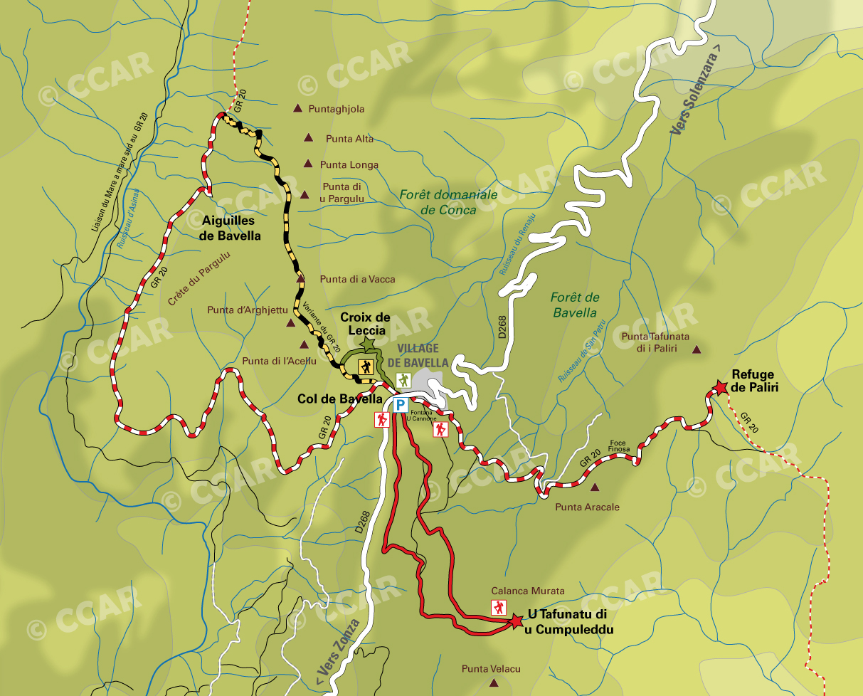
The hole bomb

U Tafonu di u Cumpuleddu
Altitude: Beginning parking 1 218 m-3996ft 03⁄4in
Height: 200 m- 656ft 21⁄64in
Length: 3 hours return
A nice walk in the forest of Laricio Pins ends at the hole of the bomb, a natural curiosity caused by erosion. Near to the Punta Velacu, at 1483m (4865ft 553⁄64in) we will be able to observe all the strength of the elements. Very easy hiking path, only the approach of the hole is delicate.
Signalisation/markers: red and cairns
Cross of Leccia
Altitude: Start Col de Bavella 1218 m-3996ft 03⁄4in
Height: 200 m- 656ft 21⁄64in
Length: 2 hours return
Difficult hiking path, equipment recommended, steep and rocky path.
Signalisation/markers: Green
Refuge of Paliri
 Altitude: Beginning fountain of Cannone 1183 m-3881ft 251⁄64in
Height: 400 m-1312ft 41⁄32in according to the options.
Length: 4 hours return to the refuge
Easy hiking path to go the Col of Finosa then go along watershed of Paliri up to the refuge.
Signalisation/markers: Red and White GR20
Variante Alpine du GR20
Altitude: Beginning Col de Bavella 1218 m-3996ft 03⁄4in
Height: 500 m- 1640ft 53⁄64in with the highest point at the Col de Pargulu at 1 662m-5452ft 95⁄64in.
Length: 4 hours return for the Punta di u Pargulu and 7 hours for the complete lap with return on the GR20
Accessible to the well-informed walkers. Marked hiking path with a delicate part secured by a cable. The return by the GR20 is easy but monotone in comparison. Equipment recommended.
Signalisation/markers: Two yellow lines on the variante alpine du GR20, red and white on the GR20 with cairns
Complementary information:
In the tourism office (point Info de l’Alta Rocca in French) located in Sainte Lucie de Tallano and Zonza.
Renseignements Complémentaires :
Dans les bureaux d'information touristique de Levie, Sainte Lucie de Tallano, Aullène, Bavella, Sari-Solenzara