Les randonnées

Les boucles au coeur de l'Alta Rocca
Publié le 01 août 2019LOOPS IN THE HEART OF ALTA ROCCA
In olden days, the villages were linked each other by mule tracks. Those paths which permit to trade between villages has been preserved and re-open for the touristic paths.
CLICK ON THE MAP TO ENLARGE

Zonza / Quenza / Zonza
Beginning: Coming from Levie, at 50 m-164ft 01⁄2in- on the left at the hotel the « Mouflon d’or ». Wood signalisation for the beginning. Markers: Orange
Length: 4h15. Difficulty: easy
Interest: nice walk near to the river (swimming sites). Forest of oaks.
Serra di Scopamena / Quenza / Serra di Scopamena
Beginning: at the centre of the village of Serra Di Scopamena. Markers: orange. Length: 5h00. Difficulty: Easy.
Interest: Forest crossing. Beautiful crossing on crest with panoramic points of view on the Alta Rocca area.
Patrimonial interests: Water mill in Serra Di Scopamena, Chapel from the year 1000 in Quenza, Sheepfold of Lavu Donacu and of Ghjallicu.
San Gavinu di Carbini / Gualdaricciu / Carabona / Zonza / San Gavinu di Carbini
Beginning: at 650 m-2132ft 635⁄64in- of the village of San Gavino di Carbini, on the road to Sàpara Maiò. Markers: orange.
Length: 6h00. Difficulty : Easy
Interest : beautiful shady crossings, forest of oaks and pines, chesnut.
Patrimonial interests: Church of Gualdaricciu, Churh of Carabona, bread oven of Giglio and mill of Pian di Santu.
CLICK ON THE MAP TO ENLARGE
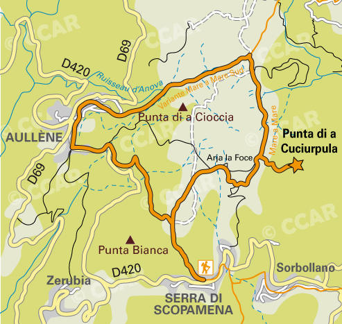
Serra di Scopamena / Aullene / Serra di Scopamena
Start: Centre of the village of Serra di Scopamena.
Length : 3h30. Markers: orange, any difficulty.
Interest : panorama on the area. Possibility to access to the Punta di Cucciurpula (1164 m- 3818ft 1049⁄64in). Allow 1 hour more for the return trip from the Col of Arghja La Foce.
Map IGN TOP 25 Petreto-Bicchisano-Zicavo.
CLICK ON THE MAP TO ENLARGE

Lap Altagene / Sarradò / Altagene
Beginning: 600 m (1968ft 63⁄64in) after the church at the heart of the village.
Markers: orange. Length: 4h00.
Difficulty: Easy
Interest: panoramic point of view at 1033m high (3389ft 119⁄64in), viewpoint indicator on the plateau of the Sarradò.
Complementary information: In the tourism office (point Info de l’Alta Rocca in French) located in Sainte Lucie de Tallano and Zonza.
Renseignements Complémentaires :
Dans les bureaux d'information touristique de Levie, Sainte Lucie de Tallano, Aullène, Bavella, Sari-Solenzara